Project Overview
CTA, in partnership with the Chicago Department of Transportation (CDOT), and the Chicago Department of Housing and Economic Development (now the Chicago Department of Planning and Development), began developing a vision for Ashland Avenue that would provide fast, reliable and convenient transportation. Together, these agencies developed a long-range plan for Bus Rapid Transit along a 16-mile stretch of Ashland, from Irving Park to 95th Street. This vision included dedicated bus lanes, signal priority for buses, limited stops and enhanced customer amenities at bus shelters.
In 2013, the CTA published the formal Environmental Assessment (EA), which is a document that provided a detailed assessment of social, economic, and environmental impacts of the project at the time. In addition to publishing the EA, CTA and CDOT held a formal public comment period that ended December 20th, 2013.
Archived Project Factsheet
 Ashland BRT Corridor Factsheet (text version)
Archived Project Videos
Archive: Why BRT on Ashland?
The following information was written as part of the Ashland BRT planning process. We are keeping it available as a public archive, although CTA is not currently advancing BRT on Ashland Avenue, and data cited may be no longer be current.
View full size (.pdf)
Project Benefits
Saves Time and Improves Reliability
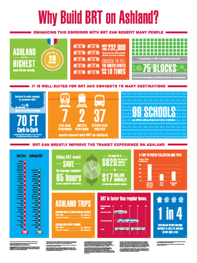
Ashland BRT would provide a transit option about as fast as driving for neighborhood residents, with an increase in bus speeds of up to 83, and a 50 percent improvement in reliability, keeping buses running regularly and on-schedule, and making travel times more predictable.
Increases Opportunities for Economic Development
The Ashland Avenue corridor is a key north-south connector that has seen residential and employment growth and is expected to attract more. According to the Chicago Metropolitan Agency for Planning, the population living within a half-mile of Ashland between Irving Park Road and 95th Street is expected to grow by 55,000 (or about 24%) by 2040. Providing a competitive transit option makes room for economic growth.
BRT has been shown to be an economic driver for a corridor, since it provides fast and reliable transit access similar to rail, which can improve access to jobs, increase foot traffic for neighborhood businesses, attract investment, and spur development.
Meets High Demand
Ashland Avenue has the highest bus ridership of all CTA routes, with 10 million boardings in 2012—more than 31,000 per weekday. Currently, 1 in 4 households located within walking distance of Ashland Avenue do not have a car.
Connects with Major Destinations and Existing Transit Network
The full 16-mile Ashland BRT would connect with seven CTA ‘L’ stations, two Metra stations, and 37 bus routes, and provide a much-needed north-south transit connection outside of the downtown area. This corridor provides access to nearly 133,800 jobs, including large employment centers such as the Illinois Medical District, and serves popular destinations like UIC, Malcolm X College, and the United Center. There are also 99 schools within walking distance of the proposed Ashland BRT.
Improves Neighborhood Streetscape
The proposal to construct BRT on Ashland Avenue includes streetscape improvements that would increase safety and pedestrian comfort, including improved lighting, ADA ramps, platforms that provide pedestrian refuge when crossing the street, and removal of left-hand turns, which are a major cause of vehicle accidents.
How it Works
The configuration for BRT on Ashland (also known as the “Preferred Alternative”) offers riders faster, more reliable service and new, amenity-filled stations with enhanced, landscaped medians between stations and along sidewalks. Local bus service will remain.
The main features include:
Dedicated center running bus-only lane in each direction to keep buses out of general traffic
- Limited stops: approximately every half-mile and at CTA stations
- Transit Signal Priority intersections and longer green lights to keep traffic moving
- Potential for paying fares at the station before boarding, similar to ‘L’ stations
- Wide doors on left side of new, high-capacity vehicles
- Real-time bus arrival information at stations
- Improved lighting at stations
- ADA ramps at stations
- Maintains most existing medians
- Adds more than 75 blocks of new landscaped medians
- Retains approximately 90% of parking and loading zones on both sides of the street
In order to accommodate BRT, the following adjustments would occur, with some impacts to general traffic:
- Dedicating two general travel lanes (one in each direction) as center-running bus-only lanes, typically leaving one in each direction. Two auto travel lanes in each direction will remain where there are currently three travel lanes (between Lake Street and Roosevelt Road).
- Small reduction in parking; approximately 90% of parking and loading zones retained on both sides of the street.
- Most left turns removed; left turns at highway access points retained.
How would travel times compare?
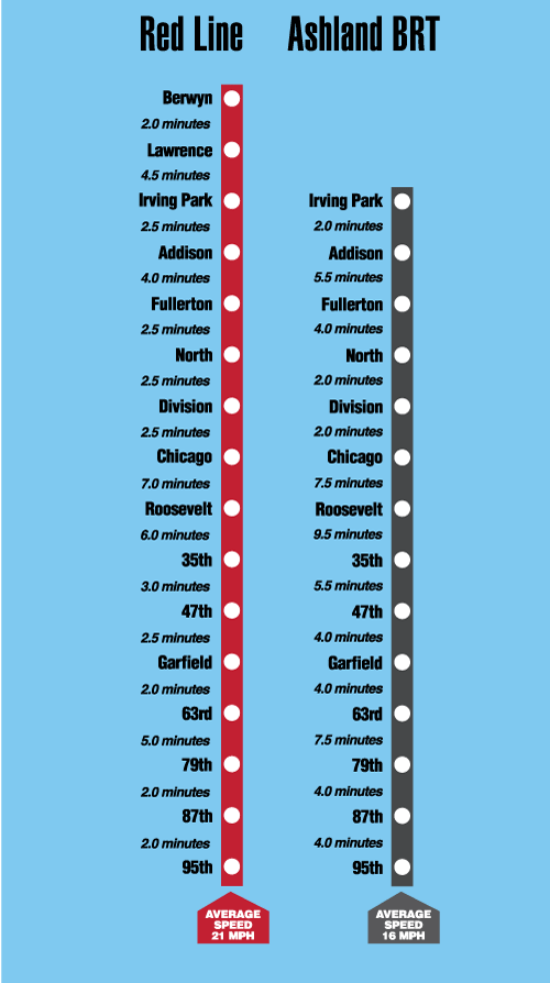
Graphic: Travel times shown reflect estimates based on the proposed center running design alternative for Ashland BRT, and Red Line operation during the fastest times of day and with no slow zones along the Dan Ryan branch.
Archived Map of Proposed Ashland BRT Stops
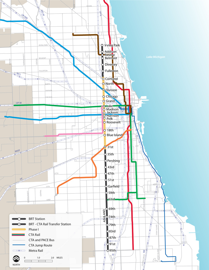
This map shows proposed stops along the complete 16-mile Ashland Avenue corridor, and the proposed first phase from Cortland Avenue to 31st Street is shaded in yellow.
Environmental Assessment (EA)
Download the Complete Ashland BRT Environmental Assessment
Ashland BRT Environmental Assessment:
- Full File Size (14 MB)
– this version is a large file size and may take time to download if you do not have a high speed internet connection.
- Reduced File Size (4 MB)
– this version contains all of the same information as the Full File Size version, but some graphics may be lower resolution.
- Text Version (1.44 MB)
Appendices to the Ashland BRT Environmental Assessment:
All of the following links are to PDF documents. Some appendices are divided into several parts because of large file sizes.
Accessible format versions of the appendices are not available online due to their size. To access an accessible format version of these appendices or if you have other questions related to the accessibility of these materials for the visually impaired, please call 312-681-4279.
Frequently Asked Questions about the Environmental Assessment (EA)
What is an Environmental Assessment?
An Environmental Assessment (EA) is a document that summarizes the results of technical analyses and reviews both positive and negative effects of a proposed project on different social, economic, and environmental factors. It considers all options and impacts and allows the CTA to work with communities to create the design that best meets the needs of each neighborhood. An EA allows the FTA to assess any potential impacts in order to determine whether to provide approval to proceed with the project. An EA is required by the FTA for certain types of projects seeking federal funds.
What does the EA for Ashland BRT analyze? What were the findings?
The EA for Ashland BRT documented the full range of possible positive and negative effects of the project along the full 16-mile corridor from Irving Park Road to 95th Street. This process analyzed the impacts of the Preferred Alternative configuration (the “Build Alternative”) as compared to existing conditions (the “No Build Alternative”).
The EA identified potential positive or negative impacts with respect to traffic, parking, neighborhoods and communities, noise and vibration, air quality, energy, and construction. A summary of the EA findings is included in the Environmental Assessment Summary (.pdf) (text version, .pdf).
How to Comment
The formal comment period for the EA has ended.
At this time, CTA and CDOT are pursuing bus priority projects on other corridors through the city and more information can be found here. As part of this new project, CTA and CDOT are planning a new public outreach process and will be taking public comment at a series of meetings to be held later in 2025 and early 2026.
Public Open House Meetings
Two public open house meetings were held at the following dates and locations.
Tuesday, December 10, 2013 6:00 - 8:00 P.M.
BENITO JUAREZ COMMUNITY ACADEMY
1450 W. Cermak Road
Chicago, IL 60608
Wednesday, December 11, 2013 6:00 - 8:00 P.M.
PULASKI PARK FIELDHOUSE
1419 W. Blackhawk Street
Chicago, IL 60642
How Did We Get Here?
We arrived at the vision for BRT on Ashland after conducting an Alternatives Analysis in 2012, a year-long planning study to assess options for BRT on Ashland and Western Avenues.
During the Alternatives Analysis process, CTA and CDOT conducted technical analysis and held six open houses to garner public input, with additional meetings held at the request of stakeholders. Dedicating two general travel lanes (one in each direction) as center running bus-only lanes was chosen as the best configuration to address community concerns. This configuration oughts to increase bus speeds, enhance streetscapes, preserve medians and parking, decrease congestion and improve safety.
How We Got Here (text version) – An archived summary of the project background, process, and Alternatives Analysis results.