The Chicago Transit Authority (CTA) and the Chicago Department of Transportation (CDOT) have established the City’s first comprehensive framework plan to improve street infrastructure for public bus service: the Better Streets for Buses Plan.
This plan lays the groundwork for ongoing bus infrastructure improvements by establishing a network of corridors to prioritize, and a toolbox of street treatments to consider as solutions. The Better Streets for Buses Plan does not assign specific street treatments to corridors, but feedback gathered through the outreach process will help guide future bus priority improvements citywide.
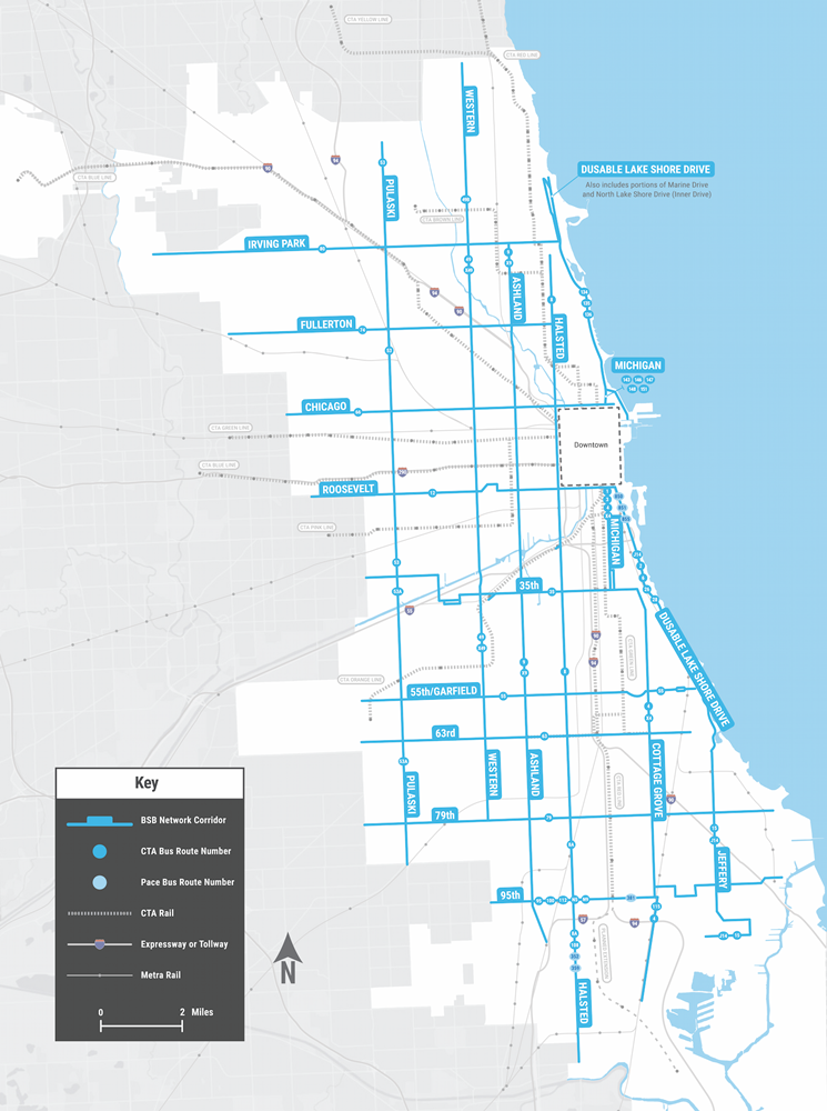
Better Streets for Buses Network
| |
Extents |
Main Routes |
| 35th Street |
31st/Cicero to 35th/Cottage Grove |
35 |
55th Street/
Garfield Boulevard |
Cicero to S Hyde Park |
55 |
| 63rd Street |
Cicero to Stony Island |
63 |
| 79th Street |
Cicero to South Shore |
79 |
| 95th Street |
Western to 92nd/Buffalo Avenue |
95/100/112/N9/N5
Pace 353 and 381 |
| Ashland Avenue |
Irving Park to Beverly/104th |
9/X9 |
| Chicago Avenue |
Austin Boulevard to Fairbanks |
66 |
| Cottage Grove Avenue |
35th to 115th |
4/X4/115 |
| Fullerton Avenue |
Grand/Nordica to Halsted |
74 |
| Halsted Street |
Waveland to 127th |
8/8A/108
Pace 352 and 359 |
| Irving Park Road |
Cumberland to Marine Drive |
80 |
| Jeffery Boulevard |
67th to 103rd/Stony Island |
J14/15 |
| Michigan Avenue |
Oak St to Chicago Avenue |
143/146/147/148/151 |
Roosevelt to 35th
Also includes Indiana between 31st and 35th |
1/3/4/X4 |
| DuSable Lake Shore Drive (DLSD) |
Grand Avenue to Foster
Also includes Marine Drive from Foster to Irving Park and North Lake Shore Drive (Inner Drive) from Irving Park to Belmont |
134/135/136/143/146/147/148 |
Roosevelt to 67th
Also includes Columbus from DLSD to Roosevelt |
6/J14/26/28
Pace 850/851/855 |
| Pulaski Road |
Peterson to 87th |
53/53A |
| Roosevelt Road |
Central to Columbus |
12 |
| Western Avenue |
Howard to 79th |
49/X49/49B |
The Better Streets for Buses Plan was published by CTA and CDOT in November 2023. The following projects and initiatives are part of implementing the Better Streets for Buses Plan through CTA and CDOT’s ongoing work to improve street design and infrastructure to make the bus riding experience better for everyone.
Bus Priority Corridor Study
Overview
The Bus Priority Corridor Study is exploring ways to make bus travel faster, more convenient, and more comfortable for riders on five key bus corridors in the Better Streets for Buses Network:
- Pulaski Road (from Peterson to 87th)
- Western Avenue (from Howard to 79th)
- Cottage Grove Avenue (from 35th to 115th)
- Fullerton Avenue (from Grand/Nordica to Halsted)
- 55th Street/Garfield Boulevard (from Cicero to S. Hyde Park)
The study is a major next step toward implementation of the Better Streets for Buses Plan.
Throughout the process, the study team will work closely with communities along these corridors to ensure their input helps shape the design concepts.
The Bus Priority Corridor Study will explore a range of possible design solutions to improve infrastructure for buses along the priority corridors. That could mean anything from a new bus boarding area that makes it easier to get on the bus, to dedicated bus lanes that help buses keep moving, even in heavy traffic.
The study will lay the groundwork for changes that can make bus travel—and streets—work better for everyone by analyzing current conditions, exploring potential improvements, gathering community input, and recommending concepts that can be advanced to final design and construction when resources are available.
Feedback from the first round of Bus Priority Corridor Study public outreach is currently being incorporated into the next round of conceptual designs. We are expecting to share refined concepts for all five corridors later in 2026 through another round of public outreach.
In the meantime, you can send the project team any comments or questions by emailing [email protected] or calling 1-888-YOUR-CTA.
Public meetings
During the first round of public outreach in late 2025, community members were invited to three in-person, open house public meetings and a virtual public meeting. At these meetings, CTA and CDOT presented and collected feedback on different street design options, allowing the public to weigh in on tradeoffs around how street space is used. Community members were also encouraged to tell us what they feel works best for their community, to make sure we understand what people currently like and dislike about the parts of the corridors they use most.
The recording of the virtual meeting is posted below, and gives an overview of the project, along with PDFs of the full set of meeting materials presented at the in-person meetings.
CTA and CDOT will host additional public meetings later in 2026 to share the refined design concepts and gather additional community feedback.
Public Meeting Recording and FAQ
English audio:
Audio en español:
Frequently Asked Questions
See below for CTA’s responses to questions received during the virtual public meeting.
In-Person Public Meeting Materials
Past Meeting Dates
Meeting 1: Gage Park Fieldhouse
Thursday, November 20, 2025
5:30 – 7pm
2411 West 55th Street Chicago, IL 60632
Meeting 2: Avondale-Logandale Elementary School
Monday, December 1, 2025
5:30 – 7pm
3212 W George Street Chicago, IL 60618
Meeting 3: Washington Park Refectory
Tuesday, December 2, 2025
5:30 – 7pm
5531 Russell Drive Chicago, IL 60637
Virtual Meeting:
Monday, December 8, 2025
6 – 7:30pm
Sign up for project updates
To learn about future public meetings and other opportunities to engage with the Bus Priority Corridor Study, sign up for our mailing list here.
Bus Priority Zones
In addition to studying corridor-length bus priority designs on the five Bus Priority Corridor Study corridors, CTA and CDOT are targeting specific “bus slow zones” as part of the Bus Priority Zone (BPZ) program. Using elements from the Better Streets for Buses Toolbox of Street Treatments, these projects are intended to make bus operations smoother and address specific slow segments and pinch-points for buses across the city. These bus slow zones—often caused by traffic congestion, insufficient space for bus boarding, or a major intersection that creates a bottleneck—can create a ripple effect of delays and bus bunching, which negatively impacts travel times and service reliability across the entire route.
In 2019, CTA and CDOT worked together to install several Bus Priority Zone projects on portions of some of the city’s most heavily traveled corridors: 79th Street, Chicago Avenue, LaSalle Street, Wacker Drive, and Western Avenue.
CTA and CDOT are currently working on the next round of BPZ installation, which will bring further bus priority elements to targeted bus slow zones across additional corridors, including Chicago Avenue, 63rd Street, Ashland Avenue, and Halsted Street. For more information, visit CTA’s Bus Priority Zone webpage.